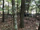
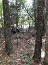
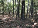
I know it's not a lot to go on...

Can anyone identify the trees in this photograph? They are tall trees, and it was hard to photograph the top of them. The reason we are interested is because we have learned through aerial imagery that this spot once had a house on it. The house was taken down sometime between 1937 and 1953 (based on aerial imagery), and trees started growing here in the 1960s and it has been woods ever since (based on aerial imagery).

IMG_0811.jpg
 
Eastern King George County, VA.

Pictures of bark and twigs attached, as close as I have for now.

The site was a homeplace and farm for over 120 years. Certain areas around where the house was are more densely populated with trees than others. We want to know what the species of trees are (ballpark), and the relative invasiveness of each, and if that explains the differences in tree density. Or if the difference in tree density could have something to do with the history of the soil, i.e., from the time when the area was a homeplace. This region was known as "The Barrens" in the 1800s because the soil is sandy and acidic.
 

Attachments

  • Close Up 1.jpg
    Close Up 1.jpg
    838.4 KB · Views: 24
  • Close Up 2.jpg
    Close Up 2.jpg
    1.1 MB · Views: 23
  • Close Up 3.jpg
    Close Up 3.jpg
    1.1 MB · Views: 22
If you can get a pic of the needle cluster, I’ll bet someone can help.

Shot in the dark from looking at the bark… maybe Virginia Pine.
 

New threads New posts

Kask Stihl NORTHEASTERN Arborists Wesspur TreeStuff.com Teufelberger Westminster X-Rigging Teufelberger
Back
Top Bottom